Description
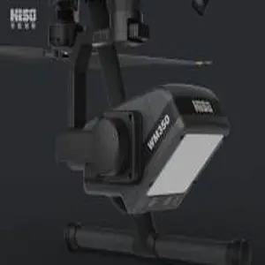
The WM350 Onboard Hydrological Current Meter is a drone-based current measurement system integrating Doppler radar and millimeter-wave radar. It is capable of measuring water flow velocity, water level, and calculating river discharge through an intelligent pre-plan system. It provides versatile service support for hydrological inspections, flood season early warning, and other scenarios.
Adopting advanced heat dissipation technology, the WM350 features excellent waterproof and dustproof performance, enabling reliable operation in harsh weather conditions. Via the DJI SKYPORT V2.0 interface, it can be directly mounted on DJI Matrice M350 series drones for use.
Technical Specifications
| Specification | Details |
|---|---|
| Weight | 900g |
| Dimensions | 130 mm×200 mm×172mm |
| Power Supply Voltage | 17V |
| Electrical Interface | DJI SKYPORT V2.0 |
| Light Parameters | Night Vision Fill Light |
| Function Modes | Gimbal Light Pitch Adjustment |
| Gimbal Light Roll Adjustment | |
| Camera | Industrial-grade dual 1080P high-definition wide-dynamic image/sensor |
| Image sensor with color RGB function | |
| Image sensor with infrared IR function | |
| Adjustable Rotation Range of Gimbal | Pitch: -120° – +30° |
| Horizontal: ±320° | |
| Roll: -90° – +45° | |
| Platform Functions | Standalone version: |
| Measure water flow velocity | |
| measure water surface height | |
| Network version: | |
| Support importing cross-section data | |
| setting parameters | |
| map point selection and route planning; | |
| Support viewing videos | |
| flow measurement data | |
| cross-section flow velocity distribution maps and comparison maps; | |
| Support real-time flow calculation and exporting flow calculation tables; | |
| Support switching between multiple offline 2D maps or video base maps; | |
| Support data recording | |
| historical data playback | |
| and data flow report export; | |
| Support multiple models of DJI drones to access the platform and display drone images in real time |


Reviews
There are no reviews yet.